In an effort to please a small minority of people who are bored with researching the story of the 1863 Battle of Gettysburg, the National Park Service is adding landscape features from the “commemorative era” of the 1880s-1920s, which will mislead and confuse the general public.This image was taken facing west at approximately 7:30 AM on Sunday, November 27, 2016.
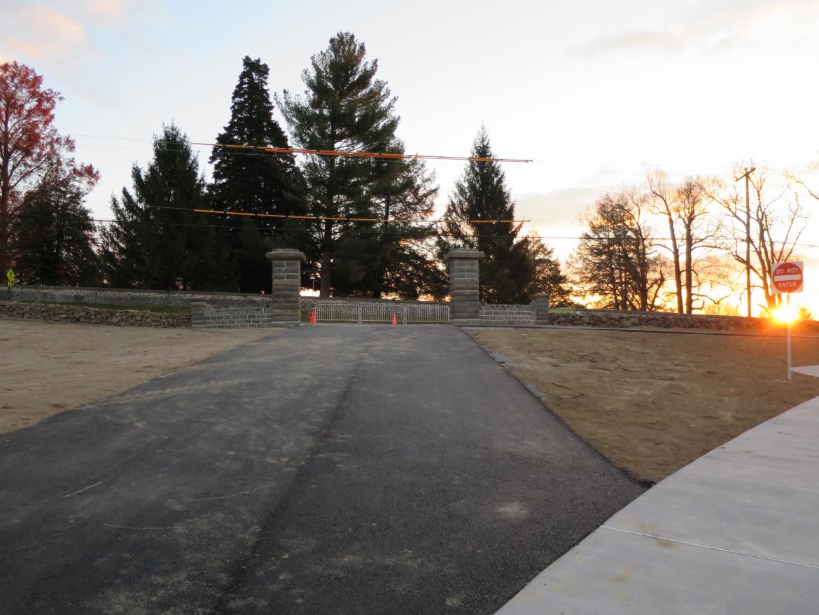
One of the commemorative era features that was recently installed is the Hancock Avenue Gate near the National Cemetery…This image was taken facing southeast at approximately 7:15 AM on Sunday, November 27, 2016.
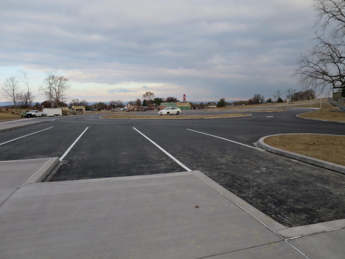
… and the newly redone National Cemetery Parking lot. This image was taken facing northwest at approximately 7:45 AM on Sunday, November 27, 2016.
The National Park Service, in a recent blog post began with the following, “Since 2000, Gettysburg National Military Park has undertaken numerous and significant projects to rehabilitate the battlefield to its 1863 appearance,” giving the reader confidence that those 1863 restoration efforts are continuing. Then, in a neat sleight of hand, the authors of the blog outline how most of the stone walls they are constructing will look like stone walls that were constructed from the 1890s to the 1920s. They have since changed the post to remove the language that says that they are constructing 1890s to 1920s walls, but they have not changed the walls.This image was taken from the “Rebuilidng Stone Walls at Gettysburg” article that was posted on December 1, 2016.
1200 tons of field stone which came from eight counties in Pennsylvania will be/have been used in the rebuilding project. This photograph shows the stone walls on the east slope of Cemetery Ridge near the High Water Mark area. The “copse of trees” is in the left background. This image was taken facing west at approximately 7:45 AM on Sunday, November 27, 2016.
The materials for the stone walls cost $198,000 in a project funded by the National Park Service. The National Park Service Historic Preservation Training Center in Frederick, Maryland is providing the labor and wall construction expertise. Notice the wooden patterns that are used to construct the pretty, well built, 1863-innacurate, stone walls.This image was taken facing southwest at approximately 7:30 AM on Sunday, November 27, 2016.
In their blog post of December 1, 2016, the National Park Service stated, “For most of these stone walls there is no photographic evidence of what they looked like, how high they were built, and whether they were stacked elegantly or thrown hastily together by the farmer clearing his fields… The walls being rebuilt are not meant to be a perfect recreation of what once existed, but rather a representation.” And with these words, the National Park Service justified placing walls from the commemorative era at the site of one of the most famous actions in military history.This view was taken facing southwest at approximately 7:30 AM on Sunday, November 27, 2016.
The National Park Service has photographs of what the walls put here during the commemorative era looked like during the 1880s-1920s. Those are the types of walls that they are placing now. Notice the rounded “rider’ stones on top of the wall.This view was taken facing southwest after 1923 and before 1960. This image is courtesy of the NATIONAL PARK SERVICE.
The National Park Service would have readers of their blog believe that they had no idea what the stone walls looked like in this area at the time of the battle in 1863. Here’s a photograph of the Hancock Avenue Gate before the stone entrance was constructed, and the stone walls at that time were replaced by the stone walls seen in the previous photograph. Although these are not the original stone walls, these stone walls are closer to the look of 1863 era stone walls at Gettysburg.This view was taken facing southwest in 1896.
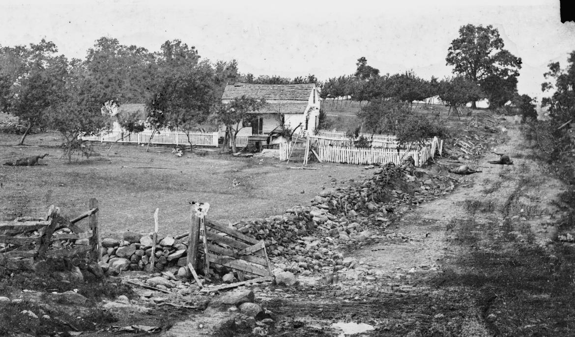
But what did stone walls look like in this area in 1863? Here is a photograph of the Leister Farm stone wall along the Taneytown Road taken a few days after the battle. Ziegler’s Grove is in the left background. Although the wall suffered damage from the battle, one can see that it was put together as most stone walls were at the time: a farmer wanted to get a rock out of his field and placed it at the edge of his property. There was not a lot of time taken to have a consistent pattern of the rocks having the same shape and size placed at the same part of the wall. They appear to have been placed more or less haphazardly as the farmer came across them in his field.This view was taken by Alexander Gardner facing northwest on July 6, 1863.
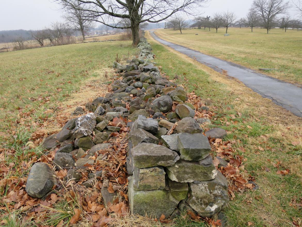
Here is a current view of the stone wall along the Taneytown Road near the Leister farm. The stones have the appearance of having been placed on the wall in no particular order or pattern.This image was taken facing northwest at approximately 11:30 AM on Monday, December 26, 2016.
In case the National Park Service doesn’t know what the stone walls looked like or how high they were in this area in 1863, here’s an 1882 photograph of the Pickett’s Charge fields taken for the Gettysburg Cyclorama. The stone wall in the foreground with the rider fence was randomly constructed. There is a “rider fence” on top, and a person leaning on/sitting on the wall to give artist Paul Philippoteaux some perspective. The wall ends at the famous “Angle” with another stone wall.This image was taken facing west in 1882. This image is courtesy of THE NATIONAL PARK SERVICE.
Here’s the same east-west stone wall at the Angle today. It is missing the rider fence, and the stones have fallen down, but it appears much like the wall in the 1882 photograph. To the left of the stone wall, near the “Angle” is the monument to the 71st Pennsylvania Infantry Regiment.This image was taken facing west at approximately 11:30 AM on Monday, December 26, 2016.
And what about the north-south stone wall at the Angle? The photographer is standing at the Angle. The monument closest to the camera is to the 71st Pennsylvania. The Round Tops are in the background. This is a low stone wall put together without a pattern. The soldiers described the stone wall in 1863 to have been about “shin high.”This image was taken facing south at approximately 11:30 AM on Monday, December 26, 2016.
As another reminder for the National Park Service to figure out what the stone walls might have looked like at the time of the battle, here’s a photograph of the north-south stone wall in the Angle area taken in 1882 for the Cyclorama painting. Below the Codori House in the left background is a figure stepping over the low stone wall to give artist Paul Philipoteaux a perspective on what Confederate General Armistead would have looked like when he came over the stone wall. The Codori Farm is in the background.This image was taken facing souththwest in 1882. This photograph is courtesy of THE NATIONAL PARK SERVICE.
For those of you who are glad that the “commemorative era” stone walls are just being confined to the Ziegler’s Grove area, guess what’s coming up the east slope of Cemetery Ridge in the High Water Mark area? The Leister Farm is in the left background.This image was taken facing east at approximately 11:30 AM on Monday, December 26, 2016.
The stone wall with the rider fence is an extension of the east-west stone wall at the Angle. To its right is the “commemorative era” stone wall. Which stone wall looks more appropriate for the battlefield in 1863?This image was taken facing east at approximately 11:30 AM on Monday, December 26, 2016.
Here is a detail from the 1882 Cyclorama painting. The correct stone wall is on the left with the rider fence. This is the same stone wall with the rider fence as seen in the previous couple of photographs. If you are going to build a stone wall on the right side/south side of this lane, because it was here at the time of the battle, shouldn’t it match the stone wall on the left side/north side of the lane?This image created facing east in 1882. This image is courtesy of THE NATIONAL PARK SERVICE.
Aside from showing everyone that you have won the “commemorative landscape” battle, what is the reason that this wall, which of course has a very inaccurate style, should be placed in this 1863 historically significant location? The Peter Frey/Basil Biggs Farm is in the right center background.This image was taken facing southeast at approximately 11:30 AM on Monday, December 26, 2016.
Let’s move north on Cemetery Ridge towards the Brian Farm. Ziegler’s Grove is in the right background. Notice the stone wall with the rider fence.This image was taken facing northwest at approximately 11:30 AM on Monday, December 26, 2016.
It could probably be a little taller, and the rocks have obviously fallen down over the years. But that begs the question, how come the Park Service isn’t just adding some of the newly purchased stones to these older fences?This image was taken facing northwest at approximately 11:30 AM on Monday, December 26, 2016.
Let’s move closer to Ziegler’s Grove and the Brian Farm and look at the stone walls that are currently there. Farmer Brian, or Farmer Ziegler, or whoever owned the property before or after them appear to have constructed these low stone walls in an indiscriminate manner. The Brian House and the monument to the 111th New York Infantry Regiment are in the background.This image was taken facing northeast at approximately 11:30 AM on Monday, December 26, 2016.
The stone walls around the Brian Farm are low, ugly, and accurate for 1863. This is the Brian Barn. The monuments to the 111th New York and to the 12th New Jersey are in the left background.This image was taken facing southwest at approximately 11:30 AM on Monday, December 26, 2016.
Let’s go about 30 yards east of the Brian Farm to Ziegler’s Grove, where the Park Service is building the new taller walls, because they claim that they have no idea of what walls would have been there at the time. Wait a minute, here is a low stone wall in Ziegler’s Grove looking like the 1863 type of stone wall. Someone has tried to arrange the stones closest to the camera into what looks like a pattern for the commemorative era walls. Big Round Top and the Meade statue are visible in the right background.This image was taken facing south at approximately 11:30 AM on Monday, December 26, 2016.
How could the Park Service miss this stone wall? Don’t they know what they are doing? The Leister Farm is in the right background. The Katherine Guinn House, also along the Taneytown Road, is in the center background.This image was taken facing east at approximately 11:30 AM on Monday, December 26, 2016.
Of course the National Park Service knows exactly what it is doing. They have conveniently provided us an example of the 1863-incorrect stone walls that they are creating on the left compared to the more 1863-correct stone walls on the right. The 1863-incorrect stone walls are approximately 48-52 inches tall. The 1863-correct stone walls are usually about 24 inches tall.This image was taken facing east at approximately 11:30 AM on Monday, December 26, 2016.
Their 1863-incorrect stone wall is an extension of the 1863-correct stone wall. The 1863-correct stone wall is out of site on the other (south) side of the wooden fence. The Brian Farm is in the right background.This image was taken facing southwest at approximately 7:30 AM on Sunday, November 27, 2016.
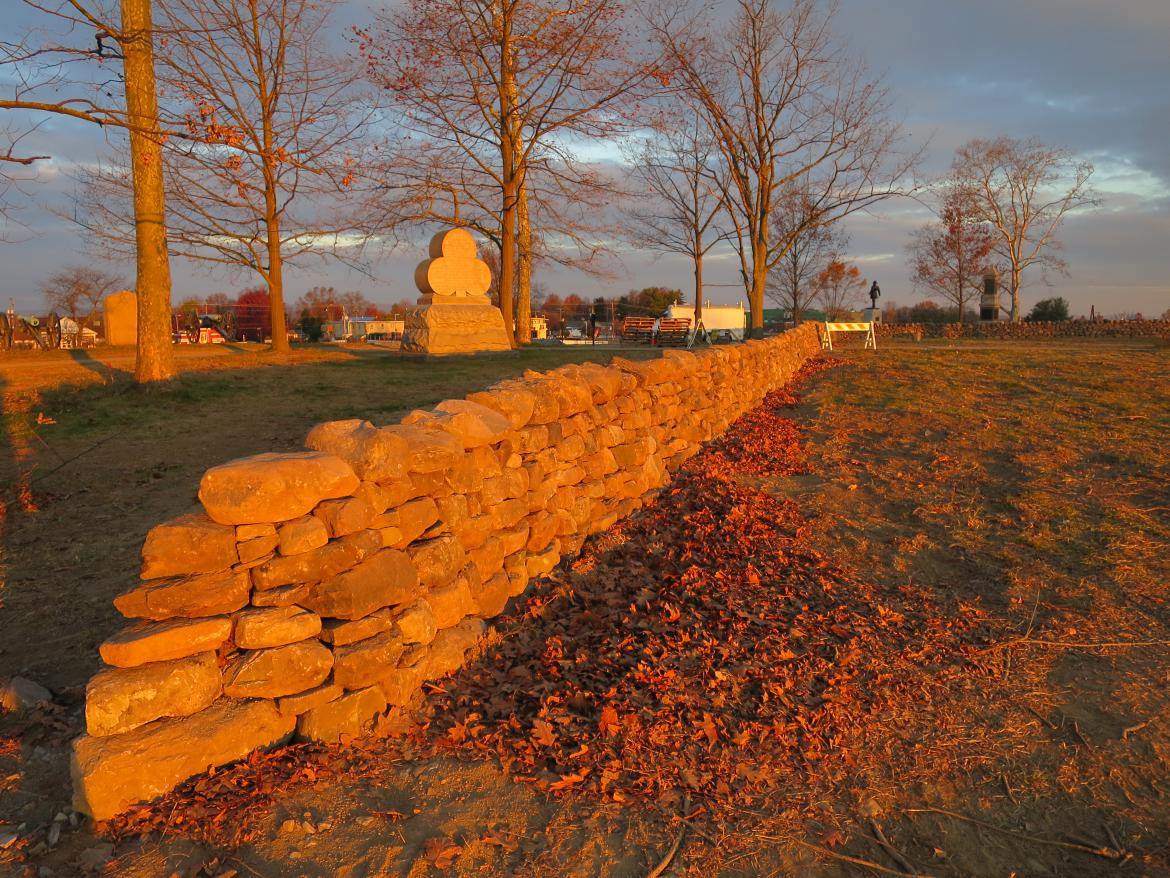
So now the National Park Service has added these pretty stone walls to the historic landscape that will confuse the average visitor.This image was taken facing northwest at approximately 7:30 AM on Sunday, November 27, 2016.
These pretty, well-constructed stone walls are the ones that visitors will think soldiers used for shelter during the battle. The monument with the large 2nd Corps trefoil/clover symbol is to the 108th New York. The statue with the man sitting is to Albert Woolson.This image was taken facing southwest at approximately 7:30 AM on Sunday, November 27, 2016.
The average visitor, or “family of four from Kansas,” as a previous superintendent used to use as an example, will be very impressed with how much time Farmer Ziegler or Farmer Brian or anyone else who owned the land around this time period carefully chose each stone and put it in the perfect position on the wall. They will probably wonder where the farmers found the time to do this work.This image was taken facing northwest at approximately 7:30 AM on Sunday, November 27, 2016.
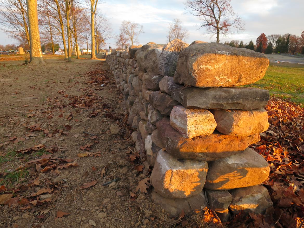
The average visitors of the future will be very impressed by how the farmers laid out the stone walls in perfect straight lines.This image was taken facing south at approximately 7:30 AM on Sunday, November 27, 2016.
The average visitors of the future might wonder if Farmer Ziegler and Farmer Brian had horses and mules the size of elephants to pull some of these stones out of the ground and use them for foundations.This image was taken facing southwest at approximately 7:30 AM on Sunday, November 27, 2016.
So some people in the National Park Service got what they wanted: a tidy “park-like” landscape of the 1920s, instead of the battlefield landscape of 1863.This image was taken facing northwest at approximately 7:30 AM on Sunday, November 27, 2016.
The average visitor comes to the Gettysburg battlefield and tours around it for two hours. Many of them believe that the landscape that they are seeing is the landscape from 1863. After all, the Park Service promotes the idea of an 1863 landscape. More than a few Licensed Battlefield Guides and locals have been asked whether or not the soldiers fought behind the monuments. The monument to the 126th New York is on the left.This image was taken facing east at approximately 11:45 AM on Monday, December 26, 2016.
Gettysburg National Military Park was established for what happened here in 1863, and most visitors come to Gettysburg for that purpose, not because of what happened from the 1890s to the 1920s. The monument to the 126th New York is in the right background.This image was taken facing southwest at approximately 11:45 AM on Monday, December 26, 2016.
Adding landscape features that were not here in 1863 confuses the average visitor. If these features are that important, a sample should be constructed inside the museum with plenty of signage, interpretation, and context.This image was taken facing northeast at approximately 11:45 AM on Monday, December 26, 2016.
The Park Service claims that the battlefield landscape is complicated and that gives them leeway to present other eras. We feel that the landscape is not that complicated. Except for the interpretive monuments and the avenues, features from 1863 or representing 1863 should be on the battlefield. Any landscape features after 1863 need to be shown/described in the museum.This image was taken facing east at approximately 11:45 AM on Monday, December 26, 2016.


